SOUTH FLORIDA – AccuWeather reports while Tropical Storm Erika brings more beneficial rain to the northern Caribbean Islands, the Bahamas and Florida are being put on alert for potential impacts this weekend and early next week.
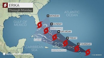
Erika remains a minimal tropical storm spinning about 245 miles east-southeast of Antigua, as of 2 p.m. EDT Wednesday (Aug. 27th).
A west to northwest track will take Erika through the Leeward Islands Wednesday night and Thursday with rain, wind and rough surf.
The exact track of Erika through the Caribbean will determine possible future impacts to the Bahamas and the southeastern United States.
“There is growing concern that Erika will threaten Florida Sunday night into Monday,” stated AccuWeather Hurricane Expert Dan Kottlowski.
Since Tropical Storm Erika is not expected to strengthen rapidly as it approaches then crosses the Leeward Islands, the system will produce more beneficial rain than widespread wind damage.
“Erika will bring needed rainfall to the northeast Caribbean Wednesday night through Thursday night with totals averaging 2-4 inches (50 to 100 mm),” stated Kottlowski.
While localized flash flooding can occur, the northeastern Caribbean is in the midst of a drought and in need of a thorough soaking, one that Danny recently struggled to produce.
“Rainfall totals over the Leeward Islands from Danny were mostly less than 1 inch. The heaviest rain total occurred at Canfield Airport on the west coast of the island of Dominica with just over 2 inches (50 mm),” said Kottlowski.

Much of the eastern half of Puerto Rico is under at least a severe drought, according to the United States Drought Monitor. Because of this, water rationing programs are in effect on the eastern side of the island.
On the other hand, the strongest winds with Erika are expected to be between 40 and 60 mph (65 to 95 kph). Such winds would be mostly in gusts and over the water, as well as over the highest terrain of the islands.
These winds could lead to isolated tree damage, sporadic power outages and localized damage to loose items and poorly built structures.
As Erika moves through the Leeward Islands and near Puerto Rico and Hispaniola, it will continue to battle dry air and increased wind shear. Interaction with the mountainous terrain of Puerto Rico and Hispaniola will also work against Erika strengthening.
Tropical systems are most likely to strengthen in areas of weak wind shear. If wind shear is too strong, the system becomes disorganized and weakens.
“As Erika pulls away from Hispaniola, it will start to encounter an environment more favorable for intensification,” said Kottlowski.
That is based on the projected track of Erika turning to the northwest and passing just north of both Puerto Rico and Hispaniola.
If Erika succumbs to the increasing wind shear, much like Danny, Kottlowski stated that it would maintain a more westward track over the mountainous islands of the Caribbean–a path that would certainly lead to its demise without any threat to the Bahamas or the United States.
However, latest indications point toward Tropical Storm Erika not experiencing the same fate of Danny and surviving the journey from the northeastern Caribbean to the Bahamas.
“If Erika can maintain a coherent core circulation after passing north of Puerto Rico and Hispaniola, it has a chance of strengthening into a hurricane as it moves through the Bahamas and towards southeastern Florida Sunday night and Monday,” added Kottlowski.
Scenarios for Erika’s track early next week range from reaching then tracking up the east coast of Florida to maintaining a more westward heading across Florida and to the Gulf of Mexico. It is also possible that Erika reaches a point where it significantly slows its forward motion around Florida.
Which scenario unfolds will depend on the strength of an area of high pressure set to build over the western Atlantic Ocean late this week and into the weekend. This high will also be responsible for bringing a shot of cooler air to the Midwest and Northeast late this week.
Should this high be strong and sit across the western Atlantic Ocean over the weekend and into next week, this could steer Erika into Florida or into the eastern Gulf of Mexico.
If a weakness in the high develops (due to a storm system moving into the eastern U.S), Erika will turn more to the north. Erika could slow down considerably if it is drawn northward, but the storm system fails to totally whisk it away to the northeast.
Regardless in all the scenarios, Erika as a hurricane or strong tropical storm would threaten communities in its path with damaging winds, flooding rain and dangerously rough surf.
Parts of Florida, especially South Florida, are in need of rain but could do without the prospect of possible hazards to lives and property. Since May 1, Fort Lauderdale, Florida, has received only 31 percent of the nearly 30 inches of rain that typically falls.
Cruise ships around the Bahamas and off the Southeast U.S. coast may be forced to re-route to different destinations.
“All interests in the Bahamas and Florida should monitor the progress of Erika closely during the next several days,” added Kottlowski.
“This is a good time for residents of the Bahamas and Florida to review hurricane plans,” said Kottlowski. “If Erika does indeed target Florida, there will be a big rush to complete preparations this weekend. However, it takes time to do some things such as moving boats from marinas to safety.”
“Be aware and do things now to mitigate flying debris,” he continued. “Even if Erika does not threaten, it is better to act on the side of caution now than wait.”
The AccuWeather Hurricane Center will continue to provide information on Erika, as well as all other tropical features across all ocean basins.
Despite a quiet first half of the hurricane season across the Atlantic, late August through September are typically the peak of tropical activity.
At this point in the hurricane season, water temperatures are at their highest. This gives disturbances moving across the Atlantic from Africa the best chance for development.
“We are also watching a tropical wave near the Cape Verde Islands, but further development seems unlikely at this time,” said Kottlowski.
In May, AccuWeather predicted eight tropical storms, four of those to become hurricanes across the Atlantic Basin during 2015. Erika is the fifth tropical storm of the season with Danny being the only storm becoming a hurricane.
ADVERTISEMENT