Eye of Dorian moving little while the Hurricane continues to pound Grand Bahama Island
By: Jeffrey Simmons
NASSAU, Bahamas – (Update as of 6pm September 2nd) – A hurricane warning remains in effect for portions of the northwest Bahamas which includes: Abaco, Grand Bahama, Bimini, and the Berry Islands.
A hurricane warning means that hurricane conditions are being experienced or could be experienced in the mentioned islands within 36 hours.
At 5pm EDT, the eye of hurricane Dorian was located near latitude 26.8 degrees north and longitude 78.4 degrees west.
This position puts the eye of Dorian about 25 miles northeast of Freeport, Grand Bahama, or 106 miles north-northeast of Bimini and 138 miles north-northwest of New Providence.
Dorian has become nearly stationary this afternoon.
A slow westward to west-northwestward motion is expected to resume overnight and continue into early Tuesday.
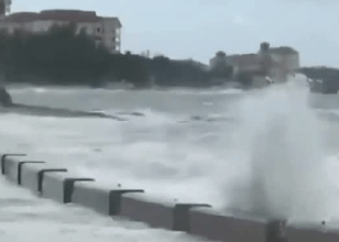
On this track, the core of extremely dangerous hurricane Dorian will continue to pound Grand Bahama Island into Tuesday morning.
Maximum sustained winds are near 145 miles per hour with higher gusts.
Dorian is an extremely dangerous category 4 hurricane on the saffirsimpson hurricane wind scale. Although gradual weakening is forecast, Dorian is expected to remain a powerful hurricane during the next couple of days.
Hurricane force winds extend outward up to 45 miles from the center and tropical storm force winds extend outward up to 150 miles from the center.
The Bahamas department of meteorology’s Doppler weather radar in New Providence and emergency management hurricane models indicate that hurricane conditions will continue in Grand Bahama through tonight and is subsiding in the abacos.
Residents in Bimini and the Berry Islands will continue to be impacted by tropical storm force winds today.
Since Dorian is slow-moving across the northwest Bahamas, a life threatening storm surge will raise water levels by as much as 18 to 23 feet above normal tide levels along the eastern, northern and western shores of abaca and the northern and southern shores of Grand Bahama through Tuesday.
Dorian is expected to produce 6 to 12 inches across the northwest Bahamas with isolated amounts up to 30 inches; in the central Bahamas rainfall amounts of 1 to 3 inches will occur with isolated amounts to 6 inches.
Flooding Conditions Have Been Reported In Several Areas On The Islands Of New Providence, Eleuthera, Andros, Exuma, Cat Island, And Long Island.
Mariners are advised to remain in port as large to dangerous swells are likely.
The next alert on hurricane Dorian will be issued at 9 pm EDT Monday, 2nd September 2019.